- Home
- What Is Geography
- Terminology
-
Curriculum
- Rationale and Aims
- Strands and Standard Elaborations
- Geograhy Competitions
- Year 7 >
-
Year 8
>
-
Year 9
>
-
Year 10
>
-
Geographies of Human Wellbeing
>
- Representing Wellbeing
- Happiness and Life Satisfaction
- UN Sustainable Development Goals
- Wealth and Income
- Access to Water
- Sanitation
- Colonisation
- Natural Resources and Minerals in Africa
- Gender Imbalances
- Wellbeing in Australia
- Strategies to Improve Wellbeing: Healthcare
- Strategies to Improve Wellbeing: Infrastructure
- Strategies to Improve Wellbeing: Education
- Organisations Improving Wellbeing
- Environmental Change and Management >
-
Geographies of Human Wellbeing
>
- Senior Geography >
-
Mapping
- Mapping Terminology
- Mapping Conventions BOLTSS
- World Maps
- World Map Projections
- Countries by Area - Largest and Smallest
- Continents and Oceans
- Regions
- Countries, States & Nations
- Types of Maps
- Choropleth Maps
- Synoptic Charts (Weather Maps)
- Direction
- Latitude and Longitude
- GPS
- Area and Grid Referencing
- Scale
- Relief
- Maps Showing Location
- Maps Showing Topography
- Maps Showing Transport
- ArcGIS
- Map Spatial Patterns and Relationships
- Cool Maps (Geography)
- Cool Maps
- Graphing
-
Skills & Figures
- Data
- Tables of Data
- Methodology in Reports
- Analysing: PQE Method
- Analysing: Calculations
- Analsying: SHEEPT Method
- Referencing
- Captions for Figures
- Referring to Figures in Reports
- Annotating Figures
- Overlays
- Photographs
- Satellite Images
- Images of a Location
- Representing Distance
- Representing Change Over Time
- Diagrams
- Fieldwork
- Interesting
- Resources
- News
- Make A Difference
- Careers

|
|
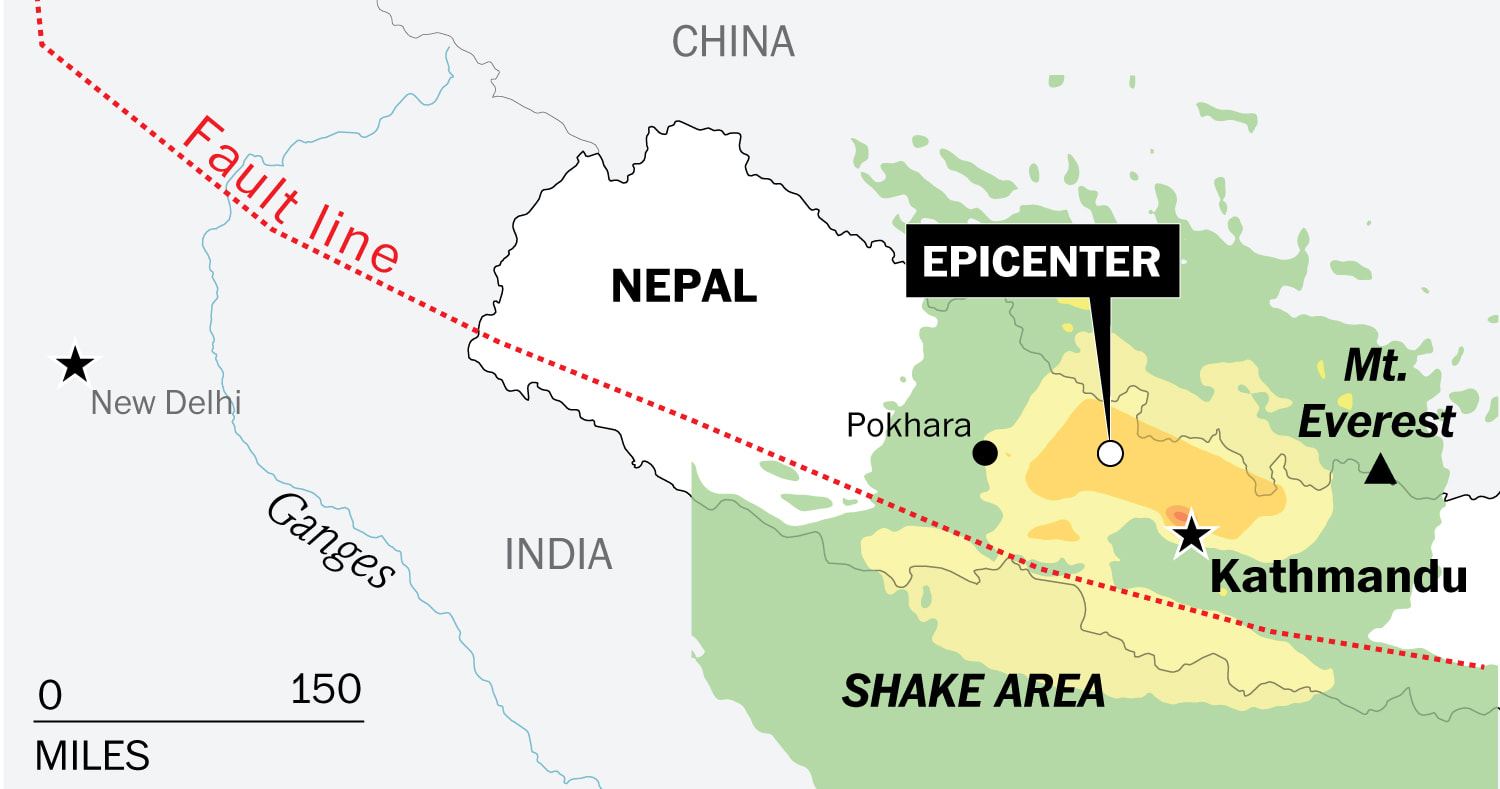
The earthquake that struck Nepal destroyed parts of Kathmandu and caused death and damage in at least three other countries. (Nepal’s Earthquake: Mapping its ripple effect across Asia - Washington Post)

The 7.8 magnitude quake struck 50 miles northwest of Katmandu in an area where the Indian continental plate, driving northeast at a rate of 1.8 inches a year, slams into the Eurasian plate. Geologists warned significant aftershocks could continue to affect the region throughout the week. (5 Maps of Nepal’s Earthquake Zone - WSJ)
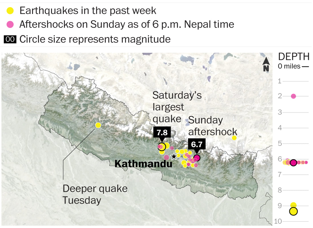
Most of the aftershocks were at the relatively shallow depth of about six miles below the Earth's surface. Shallow quakes cause more damage than deeper ones that have miles of earth to absorb the shaking. Here are all the earthquakes greater than 5-magnitude measured in the country since the 7.8-magnitude quake on the Saturday. (Nepal’s Earthquake: Mapping its ripple effect across Asia - Washington Post)

Nepal is prone to earthquakes because it is at the junction of the Indian and Eurasian tectonic plates. The Himalayas were created when the plates collided millions of years ago, and the still-moving Indian plate pushes the mountains a few millimeters higher every year. (Nepal’s Earthquake: Mapping its ripple effect across Asia - Washington Post)
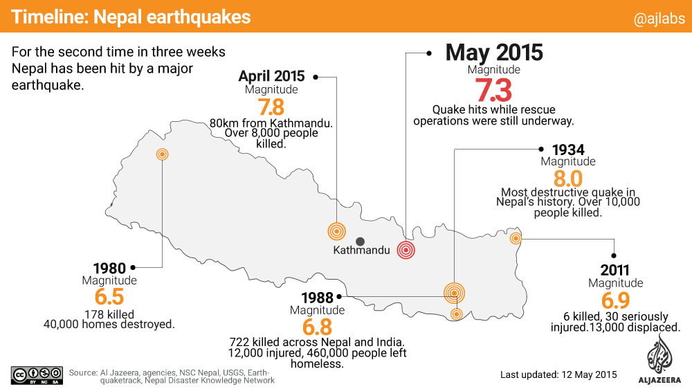
Timeline of Nepal Earthquakes (Al Jazeera)
Cause of the Earthquake

The magnitude of an earthquake is a measure of its energy; the intensity is a measure of its damage, represented on the Modified Mercalli Intensity Scale. (Nepal’s Earthquake: Mapping its ripple effect across Asia - Washington Post)
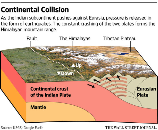
As the Indian subcontinent pushes against Eurasia, pressure is released in the form of earthquakes. The constant crashing of the two forms the Himalayan mountain range. (5 Maps of Nepal’s Earthquake Zone - WSJ)
Impacts
Before and after photographs: Nepal earthquake: Before and after photos - ABC News (Australian Broadcasting Corporation)
Photographs Showing Before and After
Photographs of the Damage

Damaged roads, landslides and heavy rains are hindering recovery efforts in Nepal after Saturday’s earthquake, despite an influx of international aid. Many affected areas are rural and only accessible by helicopter. (5 Maps of Nepal’s Earthquake Zone - WSJ)

Saturday’s quake triggered a huge avalanche that sent a wall of snow slamming through base camp and killed at least 17 people. (5 Maps of Nepal’s Earthquake Zone - WSJ)

- Home
- What Is Geography
- Terminology
-
Curriculum
- Rationale and Aims
- Strands and Standard Elaborations
- Geograhy Competitions
- Year 7 >
-
Year 8
>
-
Year 9
>
-
Year 10
>
-
Geographies of Human Wellbeing
>
- Representing Wellbeing
- Happiness and Life Satisfaction
- UN Sustainable Development Goals
- Wealth and Income
- Access to Water
- Sanitation
- Colonisation
- Natural Resources and Minerals in Africa
- Gender Imbalances
- Wellbeing in Australia
- Strategies to Improve Wellbeing: Healthcare
- Strategies to Improve Wellbeing: Infrastructure
- Strategies to Improve Wellbeing: Education
- Organisations Improving Wellbeing
- Environmental Change and Management >
-
Geographies of Human Wellbeing
>
- Senior Geography >
-
Mapping
- Mapping Terminology
- Mapping Conventions BOLTSS
- World Maps
- World Map Projections
- Countries by Area - Largest and Smallest
- Continents and Oceans
- Regions
- Countries, States & Nations
- Types of Maps
- Choropleth Maps
- Synoptic Charts (Weather Maps)
- Direction
- Latitude and Longitude
- GPS
- Area and Grid Referencing
- Scale
- Relief
- Maps Showing Location
- Maps Showing Topography
- Maps Showing Transport
- ArcGIS
- Map Spatial Patterns and Relationships
- Cool Maps (Geography)
- Cool Maps
- Graphing
-
Skills & Figures
- Data
- Tables of Data
- Methodology in Reports
- Analysing: PQE Method
- Analysing: Calculations
- Analsying: SHEEPT Method
- Referencing
- Captions for Figures
- Referring to Figures in Reports
- Annotating Figures
- Overlays
- Photographs
- Satellite Images
- Images of a Location
- Representing Distance
- Representing Change Over Time
- Diagrams
- Fieldwork
- Interesting
- Resources
- News
- Make A Difference
- Careers