What is an Undersea Volcano?
An undersea or submarine volcano is located below the ocean surface and mostly erupts under water. There are an estimated one million undersea volcanoes that, like continental volcanoes, are located near the Earth’s tectonic plates and where they form. These volcanoes not only deposit lava, but can also spew out large amounts of volcanic ash.
According to the Global Foundation for Ocean Exploration group, about “three-quarters of all volcanic activity on Earth actually occurs underwater”. Undersea volcanic activities give rise to seamounts – underwater mountains that are formed on the ocean floor but do not reach the water surface.
Tonga volcano eruption: What we know so far | Tsunami News | Al Jazeera
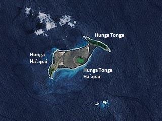
About Hunga Tonga - Hunga Ha'apai
|
The name Hunga Tonga - Hunga Ha'apai refers to the two islands of Hunga Tonga and Hunga Haʻapai that were merged as a result of the submarine volcano breaching sea level due to an eruption. The two islands are the remnants of the western and northern rim of the volcano's caldera.
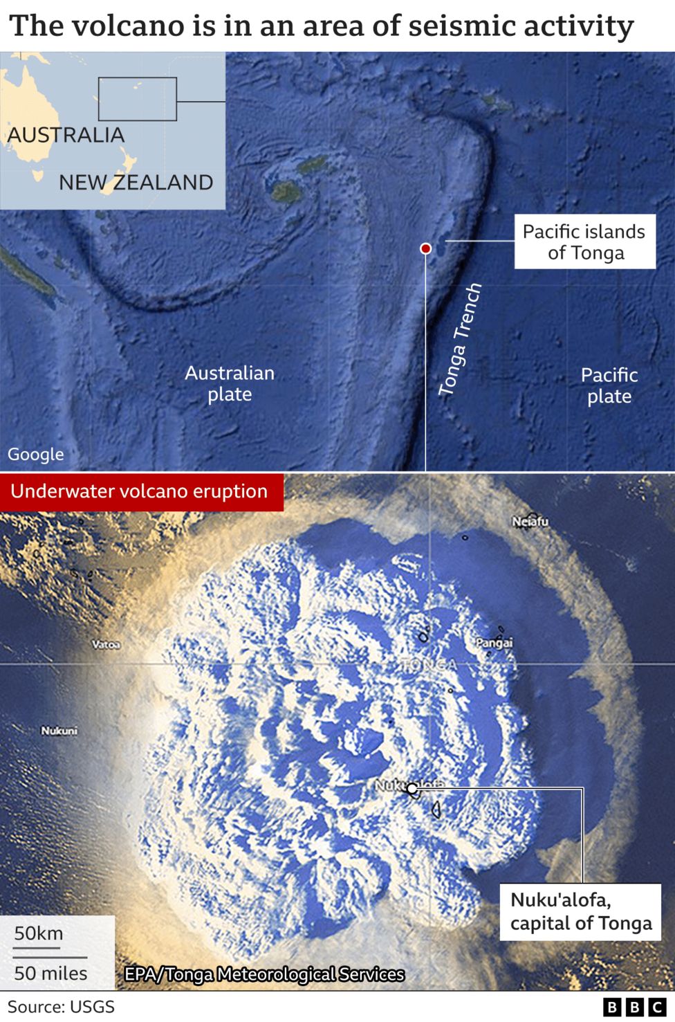
It is located about 65km north of Nuku’alofa, the capital of Tonga. The volcano is part of the highly active Tonga–Kermadec Islands volcanic arc, a subduction zone extending from New Zealand north-northeast to Fiji. It lies about 100 km (62 mi) above a very active seismic zone. The island arc is formed at the convergent boundary where the Pacific Plate subducts under the Indo-Australian Plate. |
|
|
|
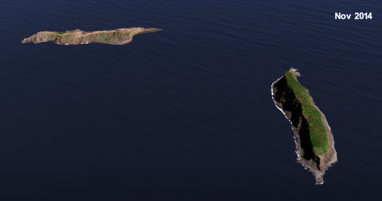
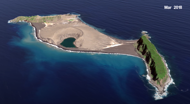
Images above are screenshots from NASA Scientific Visualisation Studio
(Visualization of Hunga Tonga Hunga Ha'apai - YouTube)
(Visualization of Hunga Tonga Hunga Ha'apai - YouTube)
Eruptions of Hunga Tonga - Hunga Ha'apai
Hunga-Tonga-Hunga-Ha’apai has a history of volatility:
Tonga volcano eruption: What we know so far | Tsunami News | Al Jazeera
- 2009: Hunga-Tonga-Hunga-Ha’apai breached sea level during an eruption.
- 2015: It erupted spewing so many large rocks and ash into the air and caused a new island to be formed measuring 2km long, 1km wide and 100 metres high.
- 2021: An eruption occured on 20 December
- 2022: An eruptions occured on 13 of January and then a massive one on 15 January, triggering a tsunami arund the Pacific.
Tonga volcano eruption: What we know so far | Tsunami News | Al Jazeera
|
Birth of a New Island: Hunga Tonga-Hunga Ha'apai
By Geography Realm. 2018 [1:01] Description: This video visualizes changes in the newly formed Hunga Tonga-Hunga Ha'apai from January 2015 to September 2017. |
|
|
The Birth of a New Island
By NASA Goddard Space Flight Center [5:27] Description: In late December 2014 into early 2015, a submarine volcano in the South Pacific Kingdom of Tonga erupted, sending a violent stream of steam, ash and rock into the air. When the ash finally settled in January 2015, a newborn island with a 400-foot summit nestled between two older islands – visible to satellites in space. The newly formed Tongan island, unofficially known as Hunga Tonga-Hunga Ha'apai after its neighbors, was initially projected to last a few months. Now it has a 6- to 30-year lease on life, according to a new NASA study. |
|
Eruption 2022

(Al Jazeera)
(BBC News)

Bureau data shows the shockwave from Hunga Tonga-Hunga Ha'apai volcanic eruption travelled at over 1000 km/h and was recorded as a noticeable jump in atmospheric pressure across Australia. By the time it reached Perth it had travelled almost 7,000 kilometres. (Bureau of Meteorology, Australia)
|
Hunga Tonga volcano erupts again, triggers tsunami
By Video From Space [1:06] Description: The Hunga Tonga-Hunga Ha'apai volcano erupted for the second time in 2 days, triggering a tsunami that hit the South Pacific Kingdom of Tonga. NOAA's GOES-West satellite captured imagery of the eruption. Huge Tonga underwater volcano eruption captured in stunning satellite video | Spac |
|
