Geography
Home
What Is Geography
7 Concepts of Geography
Introduction to Geography Video Clips
Student Testimonials - Why Study Geography?
Famous People Who Studied Geography
Geography and Environmental Quotes
Geography Memes and Jokes
Terminology
Cognitive Verbs
General Geographical Terminology
Organisations, Groups and Treaties
>
NATO
Classification of Countries and Development
Conversions of Measurement Units
Curriculum
Rationale and Aims
Strands and Standard Elaborations
Geograhy Competitions
Year 7
>
Water in the World
>
The Water Cycle
Water Scarcity and Stress
Safe and Unsafe Drinking Water
Lakes
Rivers
Place and Liveability
>
Suburbs and Housing
Improving Liveability: Increasing Green Spaces
Ghost Cities and Towns
Year 8
>
Changing Nations
>
History of Human Migration
China's Ghost Cities
Landforms and Landscapes
>
Processes Shaping Landforms
Continental Drift Theory
Plate Tectonics
>
Formation of the Himalayas
Mountains
Deserts
Wetlands
Volcanoes
>
Hunga Tonga – Hunga Ha’apai
Whakaari/ White Island, New Zealand
Earthquakes
>
New Zealand Earthquake 2011
Nepal Earthquake 2015
Türkiye and Syria Earthquake 2023
Year 9
>
Biomes and Food Security
>
Biomes
Biodiversity Loss
Anthropogenic Biomes
Domestication of Animals and Plants
Agriculture and Food Production
Impacts of Agriculture on the Environment
Food Insecurity and Hunger
The Future of Food and Farming
Addressing Food Poverty in Developed Countries
Geographies of Interconnection
>
Perceptions of Place
Transport Connections
Globalisation
Chocolate Production
Sustainably Certified Products
Fast Fashion
Palm Oil
Oil and Gas
Commercial Fishing
Modern Slavery
Year 10
>
Geographies of Human Wellbeing
>
Representing Wellbeing
Happiness and Life Satisfaction
UN Sustainable Development Goals
Wealth and Income
Access to Water
Sanitation
Colonisation
Natural Resources and Minerals in Africa
Gender Imbalances
Wellbeing in Australia
Strategies to Improve Wellbeing: Healthcare
Strategies to Improve Wellbeing: Infrastructure
Strategies to Improve Wellbeing: Education
Organisations Improving Wellbeing
Environmental Change and Management
>
Changes in Land Cover
Nature and Biodiversity
How Climate Change is Affecting Animals
Carbon Offset and Carbon Credits
Case Study: Torres Strait Islands and Climate Change
Case Study: Kiribati and Climate Change
Senior Geography
>
Rationale
Career Pathways
Course Structure
Unit 1: Responding to Risk and Vulnerability in Hazard Zones
>
Unit 1 Overview
Topic 1: Natural Hazard Zones
>
Natural Hazards in Australia
Weather and Climate in Australia
Thunderstorms
Cyclones, Hurricanes and Typhoons
Preparing for Cyclones
Floods
Tornadoes
Bushfires
Tsunamis
Landslides
Heatwaves
Droughts
Snowstorms
Topic 2: Ecological Hazard Zones
>
Endemic, Epidemic & Pandemic
Infectious Diseases
COVID-19
Plastic Pollution
Air Pollution
Invasive Animal Species
Invasive Plant Species
Unit 2: Planning Sustainable Places
>
Unit 2 Overview
Topic 1: Responding to Challenges Facing a Place in Australia
>
Urban Geography
Suburban Temperature and Heat Islands
Topic 2: Managing Challenges Facing a Megacity
>
The World's Megacities
Future Megacities
Urban Environments
Informal Settlements
Waste and Pollution
Indonesia's Capital City
Sustainable Buildings
Sustainable Cities
Unit 3: Responding to Landcover Transformations
>
Unit 3 Overview
Topic 1: Land Cover Transformations and Climate Change
>
Earth's Land Cover
Climate Change Overview
How Climate Change is Affecting People and Places Around the World
The Carbon Cycle
The Nitrogen Cycle
Global Circulation
The Greenhouse Effect
Temperature Anomalies
Forests
Case Study: Madagascar
Ice and Snow
Sea Level Rise
Addressing Climate Change
Topic 2: Responding to Local Land Cover Transformations
>
History of Cairns
Land Cover Change in Cairns
Cairns Land Use
Natural Processes Affecting Land Cover Change in Australia
Deforestation in Australia
Mining in Australia
Agriculture in Australia
The Murray-Darling Basin
Unit 4: Managing Population Change
>
Unit 4 Overview
Topic 1: Population Challenges in Australia
>
Australia's Population
Cairns Population
Topic 2: Global Population Change
>
Representing Global Population
Population Trends
Projected Global Population
Fertility Rates
Age Demographics
Ageing Populations
Forced Displacement of People
Impacts of Migration
Climate Change and Migration
Venezuela Economic Crisis
Afghanistan Humanitarian Crisis
Ukraine and Russia
Mapping
Mapping Terminology
Mapping Conventions BOLTSS
World Maps
World Map Projections
Countries by Area - Largest and Smallest
Continents and Oceans
Regions
Countries, States & Nations
Types of Maps
Choropleth Maps
Synoptic Charts (Weather Maps)
Direction
Latitude and Longitude
GPS
Area and Grid Referencing
Scale
Relief
Maps Showing Location
Maps Showing Topography
Maps Showing Transport
ArcGIS
Map Spatial Patterns and Relationships
Cool Maps (Geography)
Cool Maps
Graphing
Graphing Terminology
Graphing Conventions BATKIS
Types of Graphs
Compound Graphs
Scattergraphs
Population Pyramids
Climate Graphs
Microsoft Excel
Microsoft Excel - Population Data
Graph Patterns, Trends and Relationships
Cool Graphs (Geography)
Cool Graphs
Skills & Figures
Data
Tables of Data
Methodology in Reports
Analysing: PQE Method
Analysing: Calculations
Analsying: SHEEPT Method
Referencing
Captions for Figures
Referring to Figures in Reports
Annotating Figures
Overlays
Photographs
Satellite Images
Images of a Location
Representing Distance
Representing Change Over Time
Diagrams
Fieldwork
Air Temperature and Humidity
Water Quality Testing
Soil Testing
Vegetation
Quadrats
Riparian Cross Section
Field Sketching
Coasts and Sand Dunes
Interesting
Important Annual Dates and Events
Country Names
Flags
Cultures
Interesting Borders
Calendars Around The World
Bridges Around The World
Resources
Games and Quizzes
Apps
Books
Podcasts
Videos
Websites
News
Finding Out About News
World News Sources
Australian News Sources
ATSI News Sources
Other News Sources
Left Wing & RIght Wing
Analysing the News
Critically Analysing Photographs
Critically Analysing Videos
Critically Analysing Studies and Reports
Make A Difference
Reduce Single Use Plastics
Recycle Right
At Home
At Birthdays and Celebrations
Where Can I Buy Sustainable Products?
Volunteer For People
Volunteer For The Environment
Ordinary People Doing Extraordinary Things
Inspirational People and Stories
Careers
Careers In Geography
Careers In Environmental Science
Careers In Social Sciences
University Courses
Universities
TAFE
Other Pathways
Back to 'Topic 2: Ecological Hazard Zones' (Unit 1)
Back to 'Topic 2: Managing Challenges Facing a Megacity' (Unit 2)
18 November 2021 article: Lahore beats Delhi as world’s most polluted city:
Lahore smog: what is polluting air in the Pakistani city (firstpost.com)
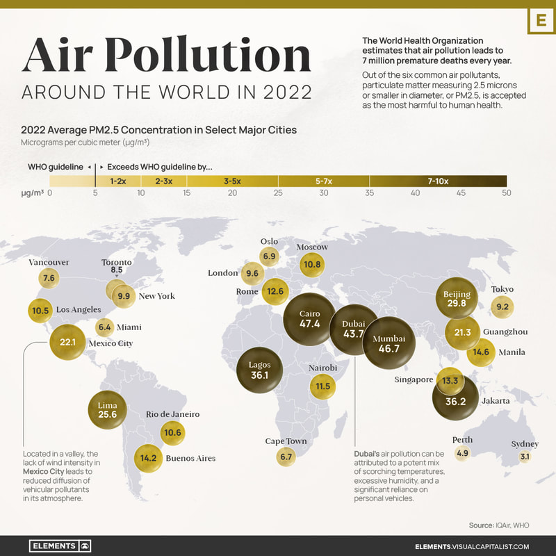
Air Pollution Around the World in 2022 (Visual Capitalist)
Read more here:
Mapped: Air Pollution Levels Around the World in 2022 (visualcapitalist.com)
The Most Polluted Cities on Earth in 2020 (Statista)
Strategies to Reduce Air Pollution
Home
What Is Geography
7 Concepts of Geography
Introduction to Geography Video Clips
Student Testimonials - Why Study Geography?
Famous People Who Studied Geography
Geography and Environmental Quotes
Geography Memes and Jokes
Terminology
Cognitive Verbs
General Geographical Terminology
Organisations, Groups and Treaties
>
NATO
Classification of Countries and Development
Conversions of Measurement Units
Curriculum
Rationale and Aims
Strands and Standard Elaborations
Geograhy Competitions
Year 7
>
Water in the World
>
The Water Cycle
Water Scarcity and Stress
Safe and Unsafe Drinking Water
Lakes
Rivers
Place and Liveability
>
Suburbs and Housing
Improving Liveability: Increasing Green Spaces
Ghost Cities and Towns
Year 8
>
Changing Nations
>
History of Human Migration
China's Ghost Cities
Landforms and Landscapes
>
Processes Shaping Landforms
Continental Drift Theory
Plate Tectonics
>
Formation of the Himalayas
Mountains
Deserts
Wetlands
Volcanoes
>
Hunga Tonga – Hunga Ha’apai
Whakaari/ White Island, New Zealand
Earthquakes
>
New Zealand Earthquake 2011
Nepal Earthquake 2015
Türkiye and Syria Earthquake 2023
Year 9
>
Biomes and Food Security
>
Biomes
Biodiversity Loss
Anthropogenic Biomes
Domestication of Animals and Plants
Agriculture and Food Production
Impacts of Agriculture on the Environment
Food Insecurity and Hunger
The Future of Food and Farming
Addressing Food Poverty in Developed Countries
Geographies of Interconnection
>
Perceptions of Place
Transport Connections
Globalisation
Chocolate Production
Sustainably Certified Products
Fast Fashion
Palm Oil
Oil and Gas
Commercial Fishing
Modern Slavery
Year 10
>
Geographies of Human Wellbeing
>
Representing Wellbeing
Happiness and Life Satisfaction
UN Sustainable Development Goals
Wealth and Income
Access to Water
Sanitation
Colonisation
Natural Resources and Minerals in Africa
Gender Imbalances
Wellbeing in Australia
Strategies to Improve Wellbeing: Healthcare
Strategies to Improve Wellbeing: Infrastructure
Strategies to Improve Wellbeing: Education
Organisations Improving Wellbeing
Environmental Change and Management
>
Changes in Land Cover
Nature and Biodiversity
How Climate Change is Affecting Animals
Carbon Offset and Carbon Credits
Case Study: Torres Strait Islands and Climate Change
Case Study: Kiribati and Climate Change
Senior Geography
>
Rationale
Career Pathways
Course Structure
Unit 1: Responding to Risk and Vulnerability in Hazard Zones
>
Unit 1 Overview
Topic 1: Natural Hazard Zones
>
Natural Hazards in Australia
Weather and Climate in Australia
Thunderstorms
Cyclones, Hurricanes and Typhoons
Preparing for Cyclones
Floods
Tornadoes
Bushfires
Tsunamis
Landslides
Heatwaves
Droughts
Snowstorms
Topic 2: Ecological Hazard Zones
>
Endemic, Epidemic & Pandemic
Infectious Diseases
COVID-19
Plastic Pollution
Air Pollution
Invasive Animal Species
Invasive Plant Species
Unit 2: Planning Sustainable Places
>
Unit 2 Overview
Topic 1: Responding to Challenges Facing a Place in Australia
>
Urban Geography
Suburban Temperature and Heat Islands
Topic 2: Managing Challenges Facing a Megacity
>
The World's Megacities
Future Megacities
Urban Environments
Informal Settlements
Waste and Pollution
Indonesia's Capital City
Sustainable Buildings
Sustainable Cities
Unit 3: Responding to Landcover Transformations
>
Unit 3 Overview
Topic 1: Land Cover Transformations and Climate Change
>
Earth's Land Cover
Climate Change Overview
How Climate Change is Affecting People and Places Around the World
The Carbon Cycle
The Nitrogen Cycle
Global Circulation
The Greenhouse Effect
Temperature Anomalies
Forests
Case Study: Madagascar
Ice and Snow
Sea Level Rise
Addressing Climate Change
Topic 2: Responding to Local Land Cover Transformations
>
History of Cairns
Land Cover Change in Cairns
Cairns Land Use
Natural Processes Affecting Land Cover Change in Australia
Deforestation in Australia
Mining in Australia
Agriculture in Australia
The Murray-Darling Basin
Unit 4: Managing Population Change
>
Unit 4 Overview
Topic 1: Population Challenges in Australia
>
Australia's Population
Cairns Population
Topic 2: Global Population Change
>
Representing Global Population
Population Trends
Projected Global Population
Fertility Rates
Age Demographics
Ageing Populations
Forced Displacement of People
Impacts of Migration
Climate Change and Migration
Venezuela Economic Crisis
Afghanistan Humanitarian Crisis
Ukraine and Russia
Mapping
Mapping Terminology
Mapping Conventions BOLTSS
World Maps
World Map Projections
Countries by Area - Largest and Smallest
Continents and Oceans
Regions
Countries, States & Nations
Types of Maps
Choropleth Maps
Synoptic Charts (Weather Maps)
Direction
Latitude and Longitude
GPS
Area and Grid Referencing
Scale
Relief
Maps Showing Location
Maps Showing Topography
Maps Showing Transport
ArcGIS
Map Spatial Patterns and Relationships
Cool Maps (Geography)
Cool Maps
Graphing
Graphing Terminology
Graphing Conventions BATKIS
Types of Graphs
Compound Graphs
Scattergraphs
Population Pyramids
Climate Graphs
Microsoft Excel
Microsoft Excel - Population Data
Graph Patterns, Trends and Relationships
Cool Graphs (Geography)
Cool Graphs
Skills & Figures
Data
Tables of Data
Methodology in Reports
Analysing: PQE Method
Analysing: Calculations
Analsying: SHEEPT Method
Referencing
Captions for Figures
Referring to Figures in Reports
Annotating Figures
Overlays
Photographs
Satellite Images
Images of a Location
Representing Distance
Representing Change Over Time
Diagrams
Fieldwork
Air Temperature and Humidity
Water Quality Testing
Soil Testing
Vegetation
Quadrats
Riparian Cross Section
Field Sketching
Coasts and Sand Dunes
Interesting
Important Annual Dates and Events
Country Names
Flags
Cultures
Interesting Borders
Calendars Around The World
Bridges Around The World
Resources
Games and Quizzes
Apps
Books
Podcasts
Videos
Websites
News
Finding Out About News
World News Sources
Australian News Sources
ATSI News Sources
Other News Sources
Left Wing & RIght Wing
Analysing the News
Critically Analysing Photographs
Critically Analysing Videos
Critically Analysing Studies and Reports
Make A Difference
Reduce Single Use Plastics
Recycle Right
At Home
At Birthdays and Celebrations
Where Can I Buy Sustainable Products?
Volunteer For People
Volunteer For The Environment
Ordinary People Doing Extraordinary Things
Inspirational People and Stories
Careers
Careers In Geography
Careers In Environmental Science
Careers In Social Sciences
University Courses
Universities
TAFE
Other Pathways