Latitude and Longitude
Latitude and longitude are the lines that go across, and up and down, on maps.
Latitude and longitude is a system which has been developed over many centuries.
The location and measurement of latitude and longitude essentially involved complex mathematics (especially geometry) and a series of international agreements/conventions for recording locations on the surface of the Earth.

Latitude

|
Lines of latitude
|
|
Significant lines of latitude:
|

|
Longitude

|
Lines of longitude
|
For a considerable period of time, the issue of which line of longitude was to be the primary line could not be agreed. Different locations were chosen due to religious and political reasons. In October 1884 at the International Meridian Conference, it was agreed that the line of longitude that runs through the Royal Observatory in Greenwich, England was to be adopted as the standard primary line of longitude (Prime Meridian).
Significant lines of longitude
Significant lines of longitude
- 0° - Prime Meridian
- 180° - Antimeridian or 180th meridian (180°E and 180°W are the same line)
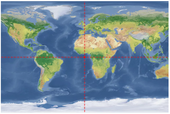
Hemispheres
The creation of the concept of latitude and longitude resulted in the creation of the concept of Earth's hemispheres. These are:
- Northern Hemisphere - the half of the Earth which is north of the Equator
- Southern Hemisphere - the half of the Earth which is south of the Equator
- Western Hemisphere - the half of the Earth which is west of the 0° line of longitude (Prime Meridian)
- Eastern Hemisphere - the half of the Earth which is east of the 0° line of longitude (Prime Meridian)

Finding Places Using Latitude and Longitude
Put together, lines of latitude and longitude form a grid that allows us to pinpoint places and features on the Earth's surface.
Like reading the time
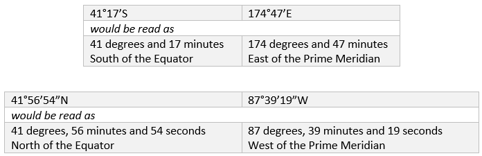
Reading latitude and longitude is similar to reading the time, in which you would start with the hour, and then narrow it down to minutes and seconds to get as precise a reading as possible. You would also specify whether it is the AM or PM.
Similarly, a coordinate reading starts with degrees, and then narrows down to minutes and seconds in order to pinpoint the exact location, ending with the hemisphere name.
General guidelines:
Symbols:
Examples:
Like reading the time
Reading latitude and longitude is similar to reading the time, in which you would start with the hour, and then narrow it down to minutes and seconds to get as precise a reading as possible. You would also specify whether it is the AM or PM.
Similarly, a coordinate reading starts with degrees, and then narrows down to minutes and seconds in order to pinpoint the exact location, ending with the hemisphere name.
General guidelines:
- Latitude and longitude are broken into degrees, minutes, seconds (DMS) and directions (N,E,S,W)
- The Earth is divided into 360 degrees.
- Each degree is divided into 60 minutes.
- Each minute is divided into 60 seconds.
- Starts with latitude, then longitude.
- Coordinates will often just contain degrees and minutes, not seconds.
Symbols:
- ° = degrees
- ' = minutes
- '' = seconds
Examples:
0 Latitude, 0 Longitude (where the Prime Meridian and Equator intersect)
- DMS Latitude and Longitude: 0°0'0.0000''N 0°0'0.0000''E
- 0° Latitude = 0°N, 0° Longitude = 0°E
Earth's Climate Zones
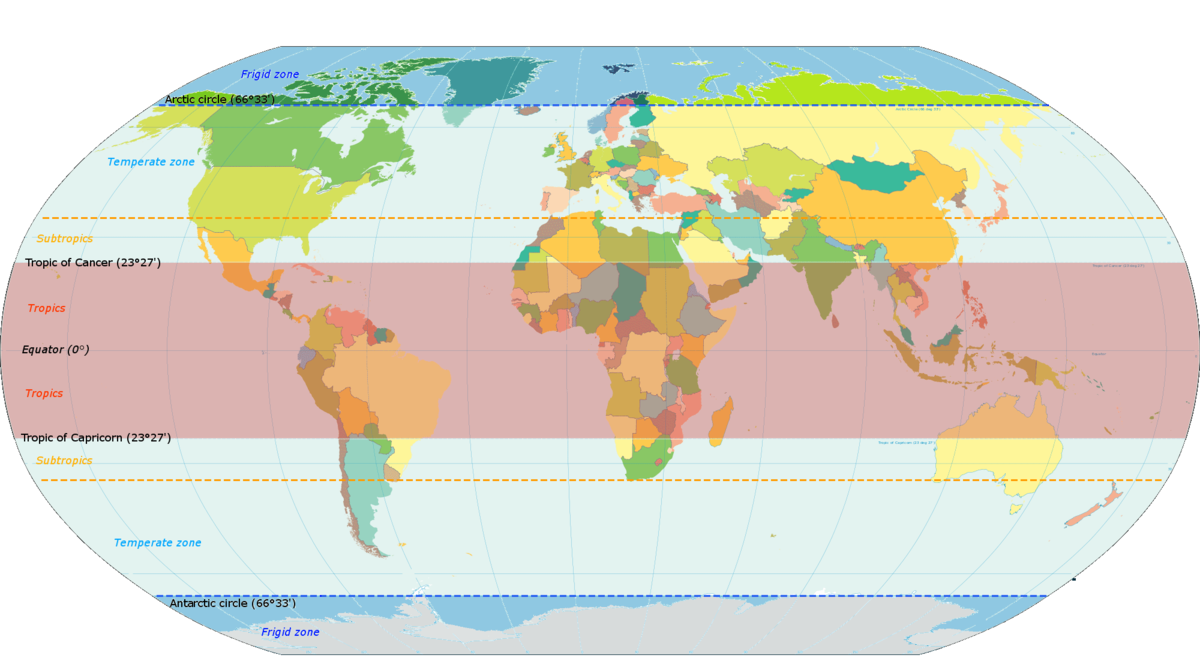
Earth's climate can be divided into three general zones according to average temperatures and average rainfall. Temperatures in these three climate zones are determined mainly by the location, or latitude, of the zone.
These three zones are:
The tropic regions of the Earth that lie roughly in the middle of the globe. They are located along the equator and between the latitude lines of the Tropic of Cancer and Tropic of Capricorn (shaded red in the map below).
These three zones are:
- polar (called 'frigid' in the map below) - is the coldest with temperatures almost always below freezing.
- temperate - contains most of the Earth’s land masses with more moderate temperatures and rainfall year-round.
- tropic - has the warmest average temperatures and gets the most rain.
The tropic regions of the Earth that lie roughly in the middle of the globe. They are located along the equator and between the latitude lines of the Tropic of Cancer and Tropic of Capricorn (shaded red in the map below).
North and South Poles
|
There are two North Poles:
1. The Geographic (or True) North Pole:
|

|
2. The Magnetic North Pole:
There are also two South Poles - Geographic and Magnetic. The Magnetic South Pole is very weak and hard to identify even if you are near it. As a result, magnetic compasses rarely point to the South Magnetic Pole.
- the point that a magnetic compass points to
- it is presently located in Canadian Territorial waters, west of Greenland. It is slowly moving in a north-westerly direction across the Arctic Ocean. It is estimated that tit is moving at a speed of about 40km per year and over the last century the Magnetic Pole has moved 1100km.
- this magnetic attraction and movement is a result of magnetic forces within the Earth.
There are also two South Poles - Geographic and Magnetic. The Magnetic South Pole is very weak and hard to identify even if you are near it. As a result, magnetic compasses rarely point to the South Magnetic Pole.
Time Zones
Until the 1890’s time keeping was a local affair. Most people regulated their day by the movement of the Sun – sunrise, noon/midday and sunset. Only the rich could afford clocks and in many places the town hall clocks or the church bells were the only source of official/consistent time.
In the late-1800’s with the development of long distance railways a problem emerged – they needed to run to a schedule and inconsistent times caused significant problems. In 1878, Canadian Sir Sanford Fleming, proposed a system of worldwide time zones based on lines of longitude. Using zones of longitude which were 15° wide he was able to divide the Earth into 24 time zones (one for each hour of the day).
The 0° line of longitude (Prime Meridian) was chosen as the start point of the system and the 180° line of longitude was the end point. To the east, time progressively became later in a day and to the west time progressively became earlier in a day. This resulted in the creation of an interesting phenomenon at the 180° line of longitude – the International Date Line.
By the mid-1900’s this had become an agreed international system, although some countries, in order to minimise time variations, have opted to choose a particular time for their whole country – regardless of where the longitudinal lines run.
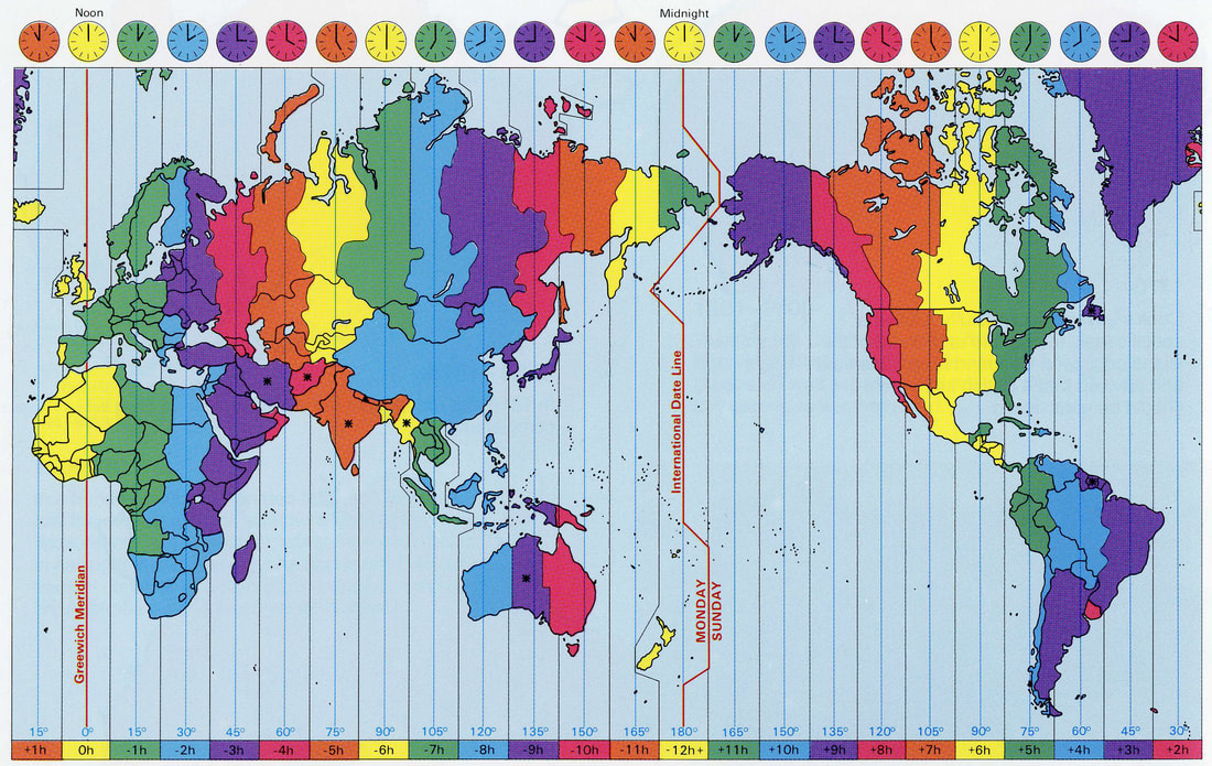
Things to note on this map include:
- How time zones in individual countries match their International or State Borders – eg:
- China, which crosses five time zones, has chosen to use only one time
- Australia and United States of America cross several time zones and they have chosen to use these times – but these are matched to State/Territory borders
- France and Spain, which are in the same time zone as the United Kingdom, have opted to use the neighbouring time zone – the same as the other countries in continental Europe
- The International Date Line does not totally follow the 180° line of longitude – rather it zigs and zags around the borders of various countries.
Google Earth - Latitude and Longitude
Website: Google Earth
|
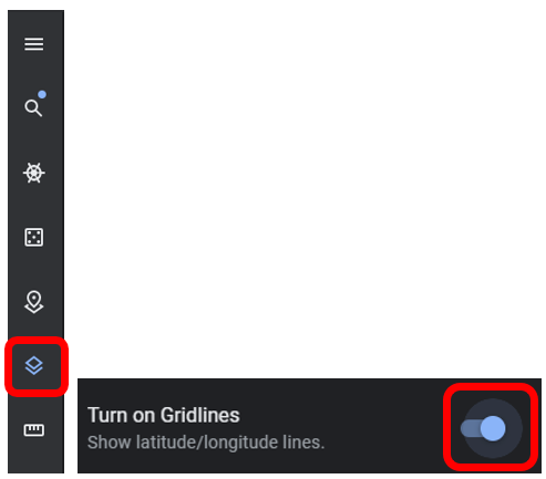
To view the latitude and longitude of places around the world
Go to the tool bar > click on 'Map Style' > Turn on Gridlines (see below) |
|
|
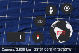
To view the coordinates
Look at the bottom right hand corner |
|
|
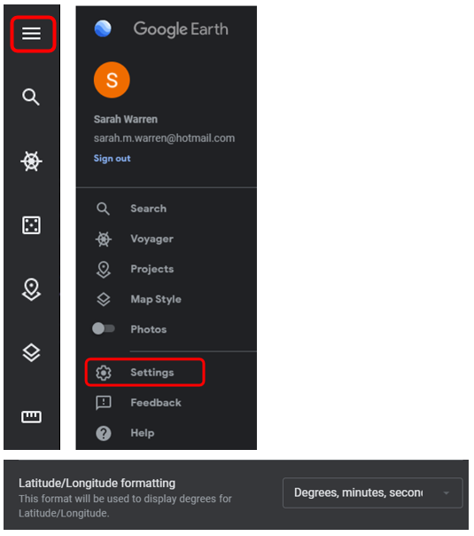
To change the format of the latitude and longitude coordinates
Go to the tool bar > 'Settings' > 'Latitude/Longitude formatting'. |
|
Google Maps - Latitude and Longitude
|
Website: Google Maps
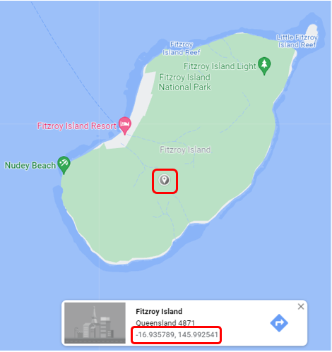
To find Latitude and Longitude coordinates using Google Maps:
|
|
Most information sourced from: Earth's Coordinate System | Intergovernmental Committee on Surveying and Mapping (icsm.gov.au)
